I remember when I first got my license three years ago, getting lost seemed part and parcel of driving to me. More often than not, I found myself anxiously flipping through the street directory (circa 2008) trying to figure out where I was. It doesn't help that with Singapore made up of mostly HDB estates, the visual similarities of the estates makes it an even greater challenge to find your way. So instead of saving precious time by driving, I ended spending more time than if I took public transport to the destination.
Thankfully though, these days (for me at least) getting lost seems to be a thing of the past. For one, the proliferation of GPS technology on mobile phones and navigation devices have made it a breeze to get around.
GPS or Global Positioning Satellite technology initially started out as a military project by the United States government. It was meant to improve the navigation accuracy of their military through the use of satellites and receivers on the ground.
Thus the introduction of the GPS navigation devices that are able to narrate directions through a speaker. These devices are usually mounted on the driver's side of the windscreen and allows the driver to view the screen clearly without taking his eyes off the road.
So advanced are these devices that they're able to provide the driver with information like the exact speed, direction and distance travelled. There're some devices that even provide warnings of known locations of speed traps. The latest devices can provide the driver with up to date traffic information that are downloaded to the device through a central server.
The GPS system is actually a constellation of 27 (24 for actual operation with 3 backups) Earth-orbiting satellites. The satellites are arranged in such a way that at any one time and at any point on Earth, there are at least four satellites overhead. Through these four satellites, a handheld GPS receiver is able to use a mathematical principle called trilateration to calculate its exact position on the ground. Over the years, the US military has allowed the civilian market access to these satellites and thus opened up a whole new way for commuters to navigate accurately.
Thankfully though, these days (for me at least) getting lost seems to be a thing of the past. For one, the proliferation of GPS technology on mobile phones and navigation devices have made it a breeze to get around.
GPS or Global Positioning Satellite technology initially started out as a military project by the United States government. It was meant to improve the navigation accuracy of their military through the use of satellites and receivers on the ground.
Thus the introduction of the GPS navigation devices that are able to narrate directions through a speaker. These devices are usually mounted on the driver's side of the windscreen and allows the driver to view the screen clearly without taking his eyes off the road.
So advanced are these devices that they're able to provide the driver with information like the exact speed, direction and distance travelled. There're some devices that even provide warnings of known locations of speed traps. The latest devices can provide the driver with up to date traffic information that are downloaded to the device through a central server.
The GPS system is actually a constellation of 27 (24 for actual operation with 3 backups) Earth-orbiting satellites. The satellites are arranged in such a way that at any one time and at any point on Earth, there are at least four satellites overhead. Through these four satellites, a handheld GPS receiver is able to use a mathematical principle called trilateration to calculate its exact position on the ground. Over the years, the US military has allowed the civilian market access to these satellites and thus opened up a whole new way for commuters to navigate accurately.
In recent times, the affordability of 3G mobile phones has brought GPS navigation to an even greater audience. In no small part thanks to internet search engine giant's efforts of creating Google Maps, a user can now get directions right on his mobile phone and accurately plot his way to a desired destination.
While pedestrians are able to hold on to their mobile devices and constantly verify their positions manually, drivers unfortunately are unable to constantly fiddle with their mobile phones while driving at speed.
For example, the latest Mio Moov 380 by the Automobile Association of Singapore provides real time information on traffic accidents and congestion through its TrafficGEM feature by alerting driver through graphics on the map displayed on a 4.3 inch screen. Information is updated in real-time through its GPRS connectivity.
The device also switches into 3D mode automatically when approaching a complex intersection. Other features include a Point of Interest search through the Yellow Pages database, warnings on upcoming ERP gantries and a carpark locator complete with parking rates! The system can even plot ERP-free routes. It can also continue its guidance in a tunnel even if the GPS signal is lost through its tunnel simulation software that matches the map of the tunnel with the vehicle's speed. The system comes pre-loaded with maps of Singapore and Malaysia.
The Mio Moov 380 currently available from AA Traffic and retails for $439.
While pedestrians are able to hold on to their mobile devices and constantly verify their positions manually, drivers unfortunately are unable to constantly fiddle with their mobile phones while driving at speed.
For example, the latest Mio Moov 380 by the Automobile Association of Singapore provides real time information on traffic accidents and congestion through its TrafficGEM feature by alerting driver through graphics on the map displayed on a 4.3 inch screen. Information is updated in real-time through its GPRS connectivity.
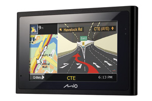 |
The device also switches into 3D mode automatically when approaching a complex intersection. Other features include a Point of Interest search through the Yellow Pages database, warnings on upcoming ERP gantries and a carpark locator complete with parking rates! The system can even plot ERP-free routes. It can also continue its guidance in a tunnel even if the GPS signal is lost through its tunnel simulation software that matches the map of the tunnel with the vehicle's speed. The system comes pre-loaded with maps of Singapore and Malaysia.
The Mio Moov 380 currently available from AA Traffic and retails for $439.